Intro:
what is a coordinate system:
A coordinate plane is an important tool for working with these equations. It is formed by a horizontal number line, called the x-axis, and a vertical number line, called the y-axis. The two axes intersect at a point called the origin.
dlo:In geometry, a coordinate system is a system which uses one or more numbers, or coordinates. To uniquely determine the position of the points or other geometric elements on a manifold such as Euclidean space.
To locate (2,5), move 2 units to the right on the x-axis and 5 units up on the y-axis. The order in which you write x- and y-coordinates in an ordered pair which is very important. The x-coordinate always comes first, followed by the y-coordinate.
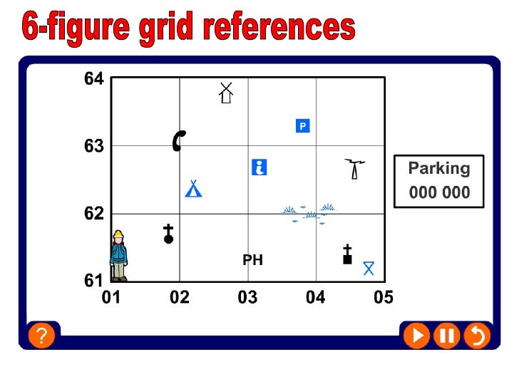
There are two main types of grid reference: four-figure grid reference, such as '19 45', indicates a 1 km by 1 km square on themap; and. six-figure grid reference, such as '192 454', indicates a 100 m by 100 m square on the map.
An easy way to remember this is that to get the first number, you go along the corridor (horizontal, x axis, east) and then up the stairs (vertical, y axis). For example, the number 2 in the diagram below is square 19 across and square 45 up and therefore, the four-figure grid reference is '1945'.

Four-figure grid references can be used to pinpoint a location to within a square measuring 1 sq km. To find the number of the square: Start at the left-hand side of the map and go east until you get to the east crossing through the bottom-left-hand corner of the square you want. Write this number down.
a column separator or row separator, Grid lines are the light grey lines that divide each of the cells, rows, and columns in a spreadsheet.
4 Figure Grid References. A four figure grid reference points you towards a particular square on a map. On all OS maps these squares represent one square kilometre. A four figure grid reference will point you to the bottom left hand corner of that particular grid square.
No comments:
Post a Comment
To support my learning I ask you to comment as follows:
1. Something positive - something you like about what I have shared.
2. Thoughtful - A sentence to let us know you actually read/watched or listened to what I had to say
3. Something thoughtful - how have you connected with my learning? Give me some ideas for next time or ask me a question.
Note: Only a member of this blog may post a comment.